

Here are a couple of observations about winged creatures who couldn’t be further apart on the basis of physical comeliness. They both play an important role in ecology, though, so let’s consider them equal in value, shall we?
Documenting a Neighborhood Wake
Alert Gazette readers might recall this post from 2019 in which I documented the presence of a red-shouldered hawk sunning itself in the next-door vacant lot. Here’s another view of that scene:
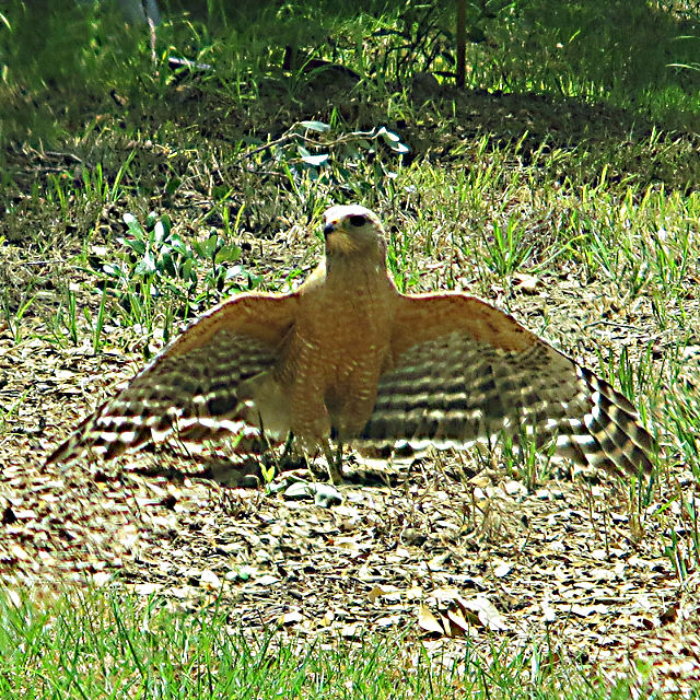
It’s easy — and often correct — to assume that birds stretch their wings in order to get warm. But there are other reasons for this behavior, including ridding themselves of ectoparasites (depending on the day’s temperature, the birds’ feathers can absorb enough heat/UV rays to kill lice). Also, it helps with the uptake of UVB rays that are important in the production of vitamin D which in turn aids in calcium absorption, necessary for healthy bones and egg-laying.
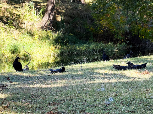
This behavior is commonly observed locally among turkey vultures (aka buzzards) and black vultures, especially after sunrise on a chilly morning where the birds roosting in trees or power line towers attempt to warm up. You might also see them do this while on the ground in groups (see the header photo at the top of the page). I always wondered if, in that case, the wing-spreading was a display of dominance or for some other social purpose. According to this article, that is indeed one reason for the behavior.
The occasion for the header photo was another large gathering of the carrion-eaters, this time on both sides of the creek near the low water crossing. Over a two-day period, I estimate that there were 25-to-40 buzzards on the ground.

Why were they there? you ask. That’s an excellent question, and for a change, I actually know the answer.
You’ll almost never see a group on the ground like that unless there’s an animal carcass nearby. In this case, an opossum had met its demise at the hands/paws of an unknown predator, although it also might have died of natural causes. The half-eaten carcass was near the edge of the creek. I’m puzzled as to why the birds hadn’t pulled it up further onto the bank, unless their feuding led to an impasse that benefited no one. [I’ll spare you the visual of what a possum carcass looks like after it’s been gnawed on for a while, to spare your delicate sensibilities. Unless, of course, you want to see it, in which case, click here.]
The More You Know…
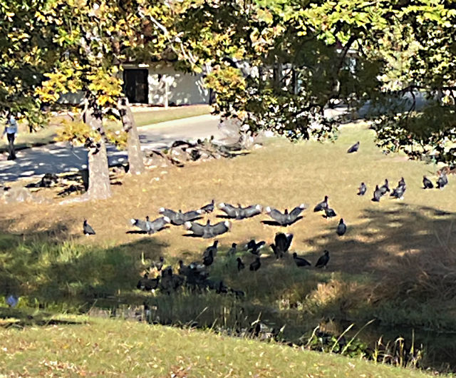
A gathering of vultures or buzzards can be referred to in three different ways depending on their activity. If they’re flying together, the group is called a kettle. If they’re roosting together in trees or on the ground, it’s a committee. But if they’re feeding on a carcass (or trying to), the group is referred to as a wake. I’m not sure about the origin of the first two names, but you can’t have a wake without a death, right?
There are also other species of birds that have group names depending on what they’re engaged in. Geese are in a gaggle on the ground or in the water, but in a skein in the air. Likewise, a group of penguins on land is called a waddle, but a raft on the water. Starlings have the coolest group appellation: a murmuration in the air, or a constellation as a general reference.
By the third day, the birds had vacated the premises, but not before wreaking havoc on the patio of the house directly adjacent to the north creek bank. They made a mess (as birds do) on the concrete and actually shredded some cushions on the patio furniture. One of the owners said it was a scene right out of The Birds. Another neighbor was so disturbed by the huge presence of the birds that she refused to go outside until they had departed.
Of course, my overriding reaction was one of curiosity, but I’m weird like that.
Job Title of the Year: Butterfly Tracker
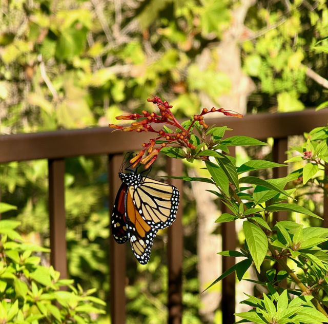
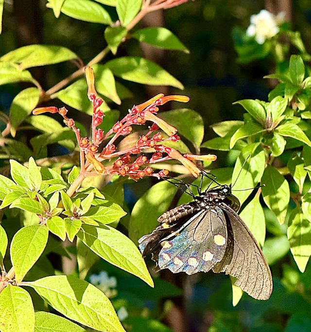
The Monarch butterflies made a brief appearance in our backyard about three weeks ago, with the occasional pipevine swallowtail (Battus philenor) mixed in. They weren’t present in such numbers as to make tree branches sag, but it was enough to make our hearts soar [sorry/not sorry].
As you’re no doubt aware, the annual Monarch migration phenomenon that those of us east of the Rockies experience begins in the north stretches of the U.S., from South Dakota to New England and even Canada (the butterflies west of the Rockies follow a different path), and end up overwintering in the mountains of southern Mexico…a journey of up to 2,000 miles. Here’s a map showing the general migration routes; click to see an enlarged version.
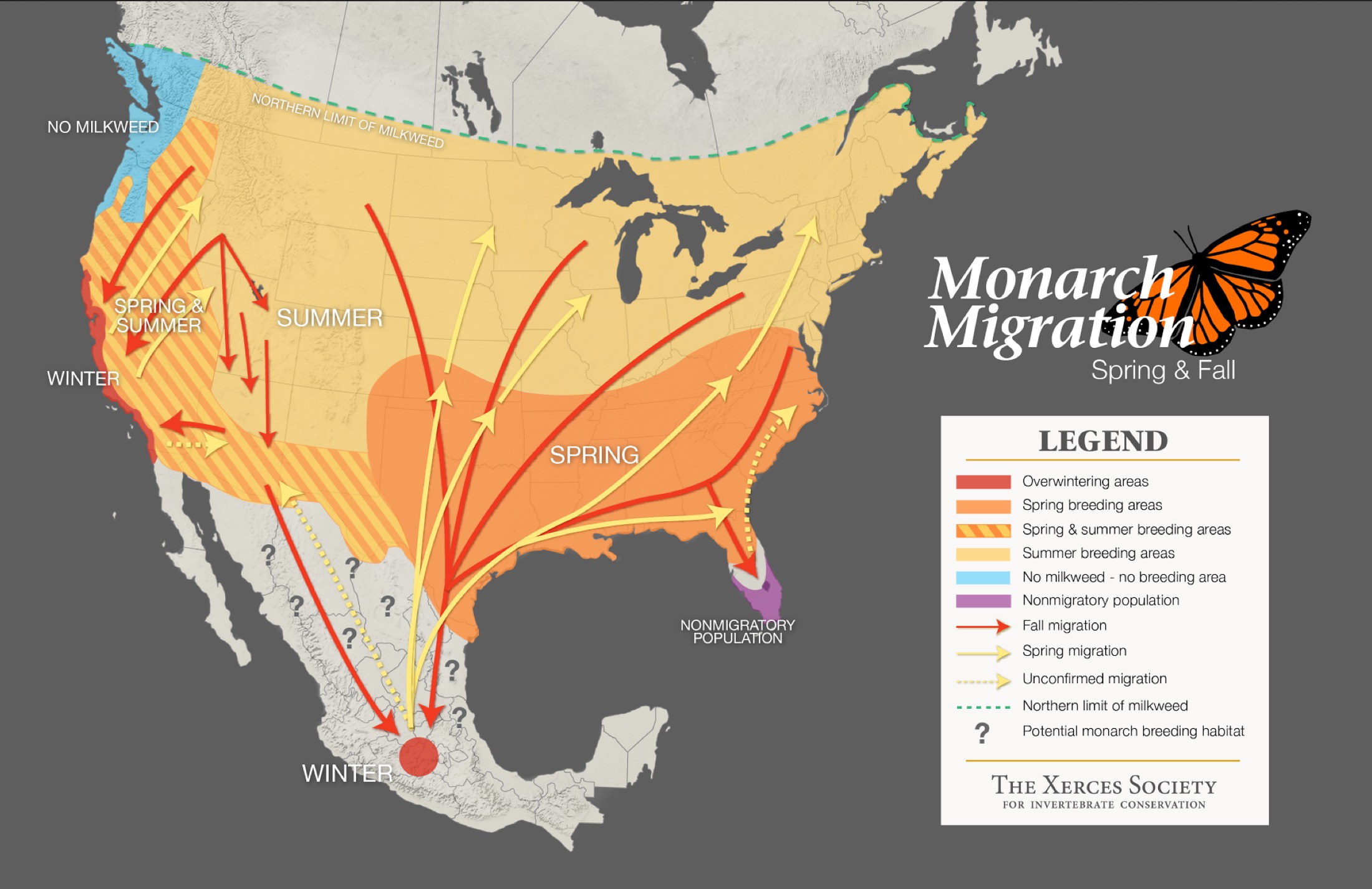
Now, the details of Monarch migration have been extensively documented so I won’t attempt to even summarize them. I heartily recommend reading this article — you’ll find that the title isn’t hyperbole — if you’re curious. But I do want to continue to focus on the migration map, and specifically how that map is being improved by some relatively new technology…and even more interestingly, how you and I can be involved in that process.
The tracking of migrating Monarchs has been done for decades; the Monarch Watch program began in 1992 and is still active. It’s the equivalent of an analog system whereby butterflies are tagged with adhesive weather-proof discs that contain a unique identifying number (here’s a YouTube video showing how to apply a tag). Anyone can order tags, fill out the data sheets, and submit them to the program, and hundreds of thousands of tags are used each year. But the data is limited to where the butterflies were tagged, and where they were eventually caught. Someone has described the process as trying to intuit the contents of a book by reading only the first and last pages.
Thanks to the development of tiny solar-powered radio transmitters — weighing 60 milligrams, or, according to ChatGPT, about the weight of a grain of table salt, a comparison that I frankly take with a grain of salt but whatever — that can be attached to individual butterflies, those insects can be tracked through the course of their migration, thereby filling in the “pages” between the beginning and end of the journey. These devices have been tested on about 400 butterflies, significantly fewer than the sticker tagging program mentioned above, but they’ve provided significantly more data to add to the understanding of the Monarch migration patterns.
What’s more, they transmit data on a frequency of 2.4 GHz, which just happens to be the same frequency that Bluetooth devices use. Can you see where we’re going with this?
All that was needed to complete the system was an interface, or receiver, for the signal sent out by the transmitter. The Monarch Joint Venture project developed an app that runs on a smartphone (or dedicated research receiver) and can automatically detect a radio-tagged butterfly that’s up to 300 feet away. The free Monarch Watch app is available for download for iOS and Android devices. The app will not only capture important data associated with a specific butterfly, but it will also upload it to a database that scientists can use to enhance our understanding of the movements and life cycle of the Monarchs.
How effective is this tracking system? Well, given the fact that there are literally hundreds of millions of Bluetooth-enabled devices between Canada and Mexico, you might think it would be pretty good…and you’d be right. Even with the limited test population, the migration map generated by Monarch Watch is several orders of magnitude better than what the sticker-tagging system generated.

Each dot in the map represents a reading taken from a receiver along the butterfly’s route. I initially questioned why some of the angles along the lines didn’t have dots which would indicate a change in direction, but I assume the lines were drawn that way to avoid obscuring other data points. At this size, the map is not very useful except on a macro basis, but it is impressive nonetheless.
Here in Central Texas, the fall migration period is over, but the spring return trip should peak in mid-March to early April, 2026. I have the app on my phone, and a reminder on my calendar, and I can’t wait to see if any radio-tagged Monarchs grace us with their presence. You should join me!
Closing Shot: IYKYK

Discover more from The Fire Ant Gazette
Subscribe to get the latest posts sent to your email.
I love Monarch Butterflies. Buzzards? Not so much.
Buzzards are not exactly cuddly, but we’d be up to our eyeballs in stinky roadkill around here without them. [It’s a dirty job but somebody’s got to do it. Just glad it’s not me. 😄]