
As I mentioned earlier, MLB and I spent a long Easter weekend in Fredericksburg, in the heart of the Texas Hill Country. It’s been our tradition for the past two decades to participate in the Easter Hill Country Tour, a bicycling event alternately sponsored by the bike clubs in Fort Worth, Lubbock, Houston and San Antonio. This year’s event was organized by the Fort Worth club.
Unlike many similar events, the EHCT is a self-paced event that allows for a lot of individual creativity in scheduling and participation. Routes of various lengths and difficulty are mapped out in advance for Friday, Saturday and Sunday. You can generally choose from mileage that varies from 25 to 75 miles, with a century (100 mile ride) each Saturday thrown in for good measure. The Sunday rides are shorter…25-40 miles. However, you can also make up your own routes; there is a seemingly infinite number of combinations of backroads around Fredericksburg and Kerrville, and the fun is often in trying to come up with new variations that still allow you to enjoy the periodic rest stops (complete with food and drink and — most important! — Porta-Potties) that are placed along the “official” routes.
After more than 1,500 miles of biking through this countryside, we’re pretty comfortable doing our own thing. In fact, we don’t enjoy riding with large groups of people that much anyway. For one thing, pacing is problematic, and there are some associated hazards (watch any Tour de France video to get an idea). We usually arrive early and ride on Thursday, before the Tour begins. We’ll then generally ride one of the organized routes (or a variation thereof) on Friday and Saturday.
Depending on how we feel, and the weather conditions, we may or may not ride on Sunday morning before returning home.
This year, we rode with the Tour only one day, on Friday. We rode alone on Thursday and Saturday, and the weather kept us off the bike on Sunday. We ended up with just over 125 miles of riding. More about that in a moment.
The EHCT is actually based in Kerrville, which is about 22 miles south of Fredericksburg (hereafter referred to as “Fburg”). But we stay in a bed and breakfast just outside of Fburg that’s so wonderful that we’re willing to tolerate the drive to Kerrville as needed. Fortunately, in most years the Tour has one day of routes that all begin and end in Fburg, so that’s one less car trip we have to make.
[Note: Hereafter, the thumbnail images are linked to larger versions of the photos…some are much larger, in case you’re on dial-up. You can also click on the first image below and begin a photo tour without all my boring narrative if you wish. But you’ll have to backtrack in order to return here, as there are no links leading back to the Gazette.]
The B&B (which shall remain nameless in order to protect our ability to get future reservations…it does not suffer from a dearth of business! 😉 is a couple of miles out of town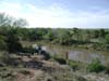 and has about a quarter mile of riverfront along the Pedernales (see photo at right). It’s got its own nature trail, and we’ve spotted deer, armadillo, rabbits, fox, snakes and turtles while wandering through it. You can sit on the screened-in back porch and watch the deer wander past in the morning and evening, or relax in an outdoor hot tub with the same view. It’s a one-family B&B, so we have the run of the place to ourselves; the proprietors live in a separate house 100 yards distant. The breakfasts are hand-delivered each morning by the owners, and range from German pancakes with peach syrup, to poached eggs with bacon, to fresh fruit and yogurt parfaits. Yep, we really rough it.
We arrived mid-afternoon on Wednesday, following a drive of unsurpassed beauty. The wildflowers began appearing just south of Midland, and for the next 300 miles we were treated to a visual feast that only occurs in those infrequent years where copious spring rains combine with an early final freeze to bring out the best in the landscape.
What we viewed is essentially the legacy of one woman, Lady Bird Johnson, whose tireless campaign to beautify America beginning in the 60s still pays dividends to highway travelers across the nation. Texas has perhaps benefited the most, as one might expect given the Johnsons’ roots in the Hill Country. The Texas Department of Transportation has an ongoing wildflower seeding program, and maintains a website providing up-to-the-minute reports on flower and foliage status across the state, and the Lady Bird Johnson Wildflower Center is a native plant education and research facility located in Austin. Thanks to efforts from these organizations, one can view bluebonnets, Indian Paintbrush and many other native wildflowers in a literal non-stop parade for hundreds of miles through Texas.
In any event, our drive to Fburg was wonderful. I insist on taking a route that most Midlanders eschew: I head south to Rankin, then on to Iraan, meeting up with I-10 just west of Sheffield. It’s a slightly less direct route, and it puts us on the interstate for most of the trip.
However, I really enjoy the drive from Rankin to Iraan because of the vastness of the scenery, and I’m always interested to see how the condition of the landscape compares with previous years. The windfarms atop the mesas west and north of Iraan are also pretty spectacular in their own right. The juxtaposition of the old energy sources (the 75+ year old Yates oil field, active but declining, provides Iraan with its raison d’Ítre) against the new (the hundreds of shining white wind turbines generating electricity 24/7/365 give area ranchers a new and badly needed source of revenue) is fascinating to consider.
We unloaded the bike and I got it ride-worthy while MLB unpacked and Abbye attempted — unsuccessfully — to make friends with the farm cat. Abbye is the epitome of eternal optimism. She’s convinced that the cat will eventually become her best bud, given enough time and effort. The cat remains skeptical.
The weather forecast called for a cold front to move in on Saturday, with possible thunderstorms. We decided to do our long ride on Friday, and the wisdom of that decision was later confirmed. Before that, on Thursday, we headed out on our own to ride some of our favorite roads as a warm-up. 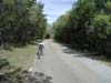 We cycled through some densely wooded areas (see photo at left; as I was taking this photo, we were rocked by a blast from a nearby granite quarry…so much for a pastoral setting!) where we’ve spotted deer and wild turkey in the past. We didn’t see any wildlife this trip as our midday arrival was not the best time to catch the critters out and about.
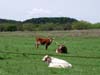
We broke out of the woods and into some cultivated pastureland, occupied by the obligatory herd of longhorn cattle (photo at right). We then headed back to town, making a side trip to the local bike shop to replace MLB’s “hydration system” (water bottles are so old school). Total mileage for the day: about 30.
One thing we discovered was the coolness of MLB’s Garmin Forerunner, which is a GPS you can wear like a sportswatch. I had bought it as a Christmas gift, thinking she’d primarily use it during her snow shoe outings and hikes, but we discovered that the altimeter and grade computation feature were perfect for cycling through the hills. There’s something reassuring about knowing that the reason we’re moving only four miles per hour up a hill is due to the fact that it’s a 12% grade. I mean, we always knew that hill was steep, but now we knew how steep. (It was also interesting to learn that Midland’s elevation is actually higher than Fburg’s, and by a thousand feet, no less.)
My parents came into town that evening, completing another tradition where they join us for the weekend. In the past, they’ve pulled a camper and stayed at the beautiful Lady Bird Johnson (she’s everywhere!) city park, but I think their camping days are now behind them. They stayed instead at a new hotel built on the grounds of the local airfield, and named, appropriately, The Hangar Hotel. It’s very nice, and recommended if you can’t get our B&B (which, of course, you can’t). Dinner that night was German cuisine (Rind Roulade with pan fried potatos and sauerkraut for me) at Friedhelm’s Bavarian Inn. One can’t spend a weekend at Fburg without eating German food.
We were in a quandary concerning our Friday ride. If the weather report was to be believed, it was likely that we wouldn’t be able to ride on Saturday afternoon, so we’d need to keep that day’s route short.
That seemed to call for a longer ride than usual on Friday. We had four choices of routes for Friday; the longest was about 75 miles and we knew we weren’t adequately prepared for that (we’d been able to ride only about 150 miles this year thanks to bad weather and other schedule disruptions). The next longest ride was 62 miles (a metric century…100 kilometers), and that was probably at the outer edge of our capabilities. However, the shorter routes covered territory we’d ridden on Thursday and just didn’t look that interesting.
The bad thing about the 62-miler is that it included what’s known locally as the Willow City Loop. This loop is one of the most beautiful, treacherous and difficult courses in the area. It’s beautiful because it has the most dense concentration of wildflowers — primarily bluebonnets — to be found in the area. It’s treacherous because it has a number of blind curves and steep drops which are often made worse by sand on the road from recent rains (and, yes, it had rained recently). In fact, we’d had a bad experience on this route a few years back, when we were still riding our upright tandem. Coming down one of those steep hills, we hit a cattle guard and flatted both tires simultaneously. Fortunately, I was able to maintain control while we came to a shaky stop. We had to be trucked off the course, the first (and only) time that’s happened to us. We had not only punctured both tubes but also ruined a tire, making an on-course repair impossible.
To compound that unnerving experience, we came to a halt just a few yards from a low water crossing where a short time before we arrived a cyclist had hit some sand and taken a nasty fall…nasty enough, in fact, to be awaiting the arrival of an ambulance. That served to intensified our shakiness from our near miss, as we saw how bad it could have been.
The treachery of the course is made worse during this time of the year by the non-stop vehicular traffic of flower-gawkers. People come from miles around to view the wildflowers, and, of course, their minds and eyes are not necessarily on the cyclists with whom they are presumably sharing the road.
I mentioned that the route is also difficult. Most of the terrain is gently rolling, but at the end there’s a long and steep climb out of the canyon that completely destroys whatever goodwill has accrued from the beauty of the first part. And, to set the proper context, it should be noted that the end of the Willow City Loop comes with almost 30 miles left in the overall route, so you can’t leave it all on that climb.
So, MLB wasn’t crazy about the idea of re-visiting the route but she let me make 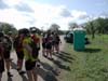 the call and I decided we should go for it.
The first part of the ride was uneventful, covering some of the same roads we traveled the day before, but in the opposite direction… a minor physical change that makes a world of perceptive difference. The weather was perfect… cool, mostly cloudless and nearly windless. The only disruption to our enjoyment was the long line in front of the Porta-John at the first rest stop. This was poor planning on someone’s part; there should be at least two of those units at the first stop of the morning, for what should be obvious reasons.
If you look at the larger photo linked to the thumbnail above, you’ll see the usual brightly colored, Lycra’d-up cycling crowd. MLB and I are drab dweebs compared to these folk: no Lycra, baggy shorts, cotton t-shirts…decidedly lo-tech apparel, in keeping with the usual recumbent rider’s reputation as the geek of the cycling world. OTOH, you’ll never overhear us complaining about aching shoulders, necks, backsides or hands, thanks to our relaxed riding positions, and we get to see the world around us as we ride, rather than staring at our front wheel or the pavement six feet ahead. Yeah, we’re slower than the rest, but we like to think that we get superior sensory input, overall. (Although I sometimes wonder when we’re still out on the course an hour after the others have loaded their bikes and headed for the hot tub!).
We pedaled onward, and at the end of a long downhill, we came to the start of the Willow City Loop. There were no surprises. The flowers were just as beautiful as advertised. At times we rode past such thick patches of bluebonnets that the air was heavily perfumed with their scent. The following photos are just a sampling of the scenery, and fail miserably in doing justice to reality.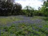
Bluebonnets are, of course, the state flower of Texas, despite some early attempts to assign that honor to the cotton boll, of all things. There are actually five species of bluebonnet, all of which are designated as “State Flowers.” Contrary to popular belief, it is not illegal to dig up a bluebonnet (although there are often right-of-way restrictions on any such activity along public roadways).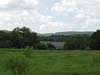
The photo at right is one that really fails to convey the amazing display of wildflowers. The field in the background appears to the casual eye to be a nice pond or small lake, the blue water contrasting nicely with the surrounding green vegetation. Of course, in reality, this is a large stand of wildflowers…a literal “sea” of bluebonnets.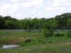
Most of the trees along this route are live oaks and mesquite. If there are any willows along this route, I missed ’em. (Willow City is actually a tiny hamlet — the proverbial wide spot in the road — at the beginning of the route; I’m sure it’s overrun with willows.) Mesquites are the Rodney Dangerfields of the tree world, but I find them to be amazing and beautiful when allowed to assume something other than shrublike proportions.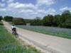
In the photo at right, MLB consents to be a part of the tableau. Actually, that was a role we played throughout this part of the ride. The other side of the road was lined with people taking photos of the flowers, and more often than not their cameras swung around to us as we came upon them. After all, bluebonnets are a common sight, but how often do you see a tandem recumbent? And, at that point early in the ride, we were still somewhat photogenic, at least compared to the mewling, quivering, debilitated creatures we would soon become.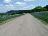
In this photo you can see rows of white flowers that formed a natural backdrop for the bluebonnets. MLB thought they were a mallow of some sort; she’s much more knowledgeable than me about such things. They looked like weeds to me, but that’s the general nature of most wildflowers anyway.
We rode deeper into the Loop and the terrain got more challenging. Through the pedals, I could feel MLB tensing up as we swooped into the draws and around the aforementioned blind curves, and I kept a close rein on our speed to reassure her. At one point we were passed by three young women who were obviously serious about their riding — and their lycra. A couple of minutes later, we dove into a particularly nasty-looking curve and spotted some sand at the bottom. I braked well in advance and we eased through it, to find that one of the women who had just passed us wasn’t quite as observant. She was stretched out across the road, bike on top of her and a nasty bruise already appearing along the entire length of one leg. Her partners were turning around and coming back to check on her. We asked if she needed help and she waved us on. It was a reminder of the consequences of inattention and/or bravado.
On we went, passing an endless stream of cars and motorcycles making the Loop in the opposite direction. That was a blessing…the bicycle route ran the opposite of that of most of the motor-driven vehicles, which greatly minimizes the chances of unfortunate encounters. But it still took some of the luster from the beauty of the surroundings.
It finally came time to climb out of the valley, and we could see clearly what lay ahead. I stopped to take a couple of pictures (and to try to summon some extra energy), then we made our slow way up the hill.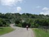
It might be edifying to understand what it’s like to climb a really steep hill on a bicycle. Unless you have the legs and anaerobic threshold of Lance Armstrong, your climbing success will be directly proportional to your gearing. If you can gear down low enough to spin up the hill, even at very low speeds, you can likely climb any hill of reasonable gradient and length. Of course, the definition of “reasonable” will vary.
This applies to all bicycles, recumbent or upright. However, the advantage the latter holds over the former is that the rider can, as needed, stand up on the pedals and bring the whole body’s weight to bear for additional power. This advantage can be significant.
The only glaring weakness of the recumbent riding position comes to the fore in these climbing situations. We have no choice but to use our legs and only our legs to spin up the hill. Standing up on the pedals is not an option. This particular hill was long…perhaps a half mile…and steep; the grade was 11-12% for much of the climb. We were undertrained, sweating profusely in the midday sun, and had the incredible pleasure of being passed at low speeds by a long string of Harleys going our direction. At one point, we were struggling to maintain four mph. It was torture…for me, anyway. Did I mention that MLB was just chattering away on the back of the back, describing the flowers on the side of the road and the view of the canyon below?
Without belaboring the point, let me just say that this was the closest I’ve come in over 15 years to hollering calfrope and getting off and walking the hill. We’ve ridden up Vail Pass from Vail, and that wasn’t as painful as this climb. But, we made it, even as my legs started flirting with cramps.
The rest of the ride was almost anti-climactic, a blurred series of steep ups and downs that eventually led back to town. We ended the day with 67 miles, thanks to the fact that we were staying a couple of miles from the official starting point and elected to bicycle in rather than load the bike on the car and drive in. In hindsight, given our lack of training mileage coupled with the difficulty of the route, it was a very foolish thing for us to attempt. We perservered, however, and emerged exhausted but somehow gratified by the experience.
Dinner that night was at Pasta Bella, a competent little Italian restaurant just off the main drag in Fburg. I had a very good Veal Parmigiana (although, frankly, I’d have eaten boiled shoe leather by that time and enjoyed it), followed by homemade strawberry, peach and pecan ice cream at the Fredericksburg Bakery.
We awoke to heavily clouded skies on Saturday morning, and the weather forecast seemed confident in the mid-afternoon arrival of the cold front and rain. We elected to skip the rides originating in Kerrville, and set off on our own route, hoping to get in a couple of hours before the weather intruded.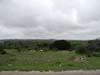
I’ll forego the excrutiating detail of the Saturday ride. It was much less demanding than the day before, and we covered some roads we’d never before seen, which is always fun. However, one downside of doing that kind of exploring is that you sometimes find yourself confronted with uncomfortable decisions about which way to turn, and during this ride we ended up traveling down a very busy State Highway 87 with no shoulder for about five miles before finding the bailout road that I knew existed…somewhere. “I’m sure it’s just over this next hill…and around this next curve…”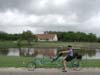
We eventually found our way onto a familiar backroad, and enjoyed riding past the full ponds that dotted the pasture through the entire route.
In the meantime, the clouds got heavier and the winds calmer, and we couldn’t help feeling that this was a sign of impending change. 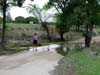 We came upon the water crossing shown in the photo at right and took that as a sign to turn around and head home, which we did, and without incident.
About an hour after getting back home, following 25 miles of riding, the calm came to an abrupt end as the front blew in, with gusty winds out of the north. An hour after that, the skies opened up and it rained…and rained…and rained. Other than an occasional lull while the front regrouped, it rained until we left for home mid-morning on Sunday. We had guessed right, and beat the weather. We hoped that no one got caught miles from home in the middle of the Kerrville rides when the front hit. Been there, done that, and it’s no fun.
As soon as we finished our Saturday ride, I trekked down the nature trail a ways to get a photo of the tree shown at right. 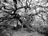 This gnarly oak tree is probably 100 years old, and I’ve always intended to take a picture and try to do something artsy with it. One variation of my Photoshopping is shown here (warning: the big image is really big). I tried to capture some of the inherently spooky quality of the tree with its moss-laden branches and Blair Witch Project-starkness.
Dinner that night was forgettable…a decent but not compelling chicken-fry at the Plateau Cafe. I would have preferred to drive to Kerrville to eat, but the weather had everyone skittish and we elected to stick close to home. Another bowl of that wonderful ice cream made up for the less-than-stellar meal.
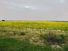
Sunday morning came in wet and cold, and we loaded up in a steady drizzle. We ran in and out of rain all the way to Sheffield, with occasional sprinkles during the last 100 miles. We were out of bluebonnet country, but even the normally drab landscape just south of Midland was still yielding surprises. I’ll leave you with this field of yellow flowers, set out for no apparent purpose other than to enthrall passers-by, in the middle of nowhere 40 miles south of home. I don’t know the species of the flower, but we’ll take all of it we can get every spring, since it means that God has again blessed our parched land with some life-giving rain.
Discover more from The Fire Ant Gazette
Subscribe to get the latest posts sent to your email.