
I’m fascinated by aerial photography, and especially by the images provided by Google Earth. Apart from their cartographic usefulness, which has assumed greater significance because of my new job, the different perspective on natural and human-created features provides a constant source of delight. Sure, there’s something of a voyeuristic thrill from peering into the neighbors’ backyards – or so I’ve heard – but the real treat is the way that features that are so familiar at ground level take on new characteristics when viewed from miles above the earth. The world somehow becomes more accessible, more comprehensible.
I have no idea how many Gazette readers share this fascination, but I want to issue a friendly challenge. I’m going to post a series of screen captures of various geographic features located across West Texas; the challenge is to see how many of them you recognize. If you’ve never lived in this area, you’ll likely have a hard time identifying any of them, and that’s OK. I wouldn’t have a clue as to what East Texas looks like from the sky. But if you’re a long-time resident of the Llano Estacado or Permian Basin, some or all of these photos should at least have a ring of familiarity to them.
There are nine photos in all. I’ll post them one at a time over the course of the next few weeks. Feel free to leave your guesses in the comments or email them to me if my sucky commenting process won’t work for you. At some point, I’ll post all the answers.
I guess it’s only fair to drop a hint for each photo. This first scene should be recognizable to anyone who’s in the oil business in West Texas. Oil fields are everywhere, but there aren’t many like this one.
Click on the picture to see a larger version.
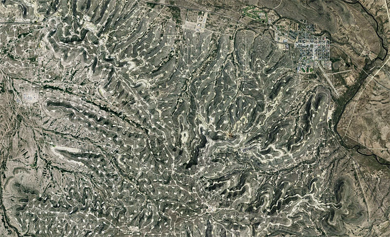
Viewed from 38,000′
Discover more from The Fire Ant Gazette
Subscribe to get the latest posts sent to your email.
My guess is the Yates Field outside of Iraan, tx. And that is the Pecos River on the right side of the photo.