
Debbie and I recently returned from a very enjoyable and occasionally adventuresome stay on South Padre Island with our good friends Sam and Trish. Their house is mere yards from Lower Laguna Madre (aka “the Bay”) which bounds the island on the west side, and an easy walk from the Gulf of Mexico (aka “the Gulf” [duh]) on the east side of the island.
If you live anywhere north or west of San Antonio, you probably know that getting to South Padre Island (hereinafter cleverly referred to as “SPI”) is a bit of a slog, driving-wise. It’s not a hard drive, just a long one. Most of the route south of San Antonio is on two interstates, first I-37 and then I-69, the latter of which deserves the title of the nation’s weirdest interstate. Feel free to look it up if you don’t believe me. Plus, it’s the only interstate highway I’ve ever driven that has 20 mph school zones in places. I’m sure there are others; I mention that fact only to warn you that speed limits along I-69 vary abruptly and precipitously, and the local constabulary maintains a constant vigilant presence along much of the route, if you get my drift.
Anyway, the drive to SPI is worth making, especially if you have such great hosts, and by “great” I mean — among more traditional definitions — the unwillingness to try to talk you out of certain foolhardy endeavors. More about that later.
We hauled our two inflatable paddle boards (Sea Eagle LB11s) plus our inflatable tandem kayak (Sea Eagle 385ft) in the bed of the truck, knowing that we’d be spending a lot of time in the water, weather permitting. Sam and Trish also have the same model of paddle boards.
Our first outing was paddle boarding on the Bay. It’s not unusual for the winds to be too strong for stand up paddle boarding (I’ve written before about my windsurfing fiasco on the Bay), but we were blessed with an absolutely calm, clear, and warm day. We ended up paddling about three miles, round trip, and had a great time.
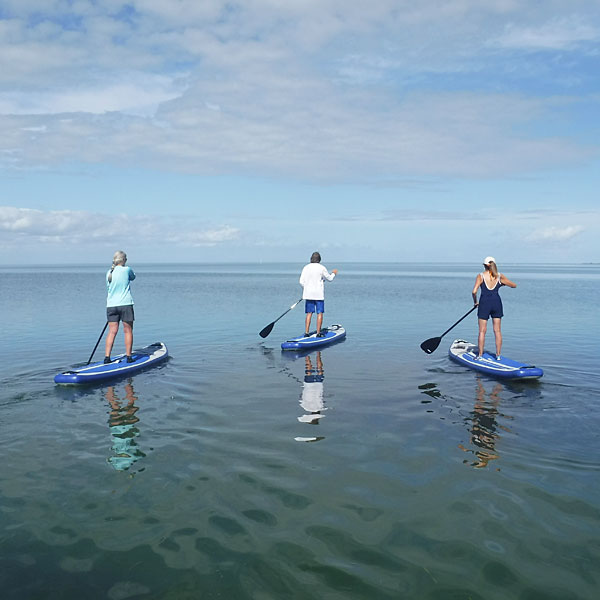
Trish, Sam, and Debbie paddling to the horizon
One of the neat things about the Bay is that it’s very shallow, averaging three feet or less except for some narrow boat channels here and there. It would be possible, albeit non-advisable — it’s about seven miles — to wade from SPI to the Texas mainland near Port Isabel. The shallow depth and calm water meant that we could observe some of the abundant sea life that thrives there, including southern stingrays, crabs, snake eels, and lots of fish of different and unknown (to me) species.
On day two, we drove forty-five miles to go ten miles. Our destination was Boca Chica Beach, where the Rio Grande empties into the Gulf. There’s no direct route to get there, so it’s 20-something miles from SPI to Brownsville, and then an almost 180-degree turn takes you back along State Highway 4 another 20-something miles, where the road dead-ends into the Gulf. Turn right onto the beach and head a couple of miles across the sand and you’ll find yourself watching as river water flows one direction and ocean water flows the other and they form a blue/brown swirl.
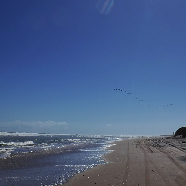
A line of pelicans head south along the shoreline at Boca Chica
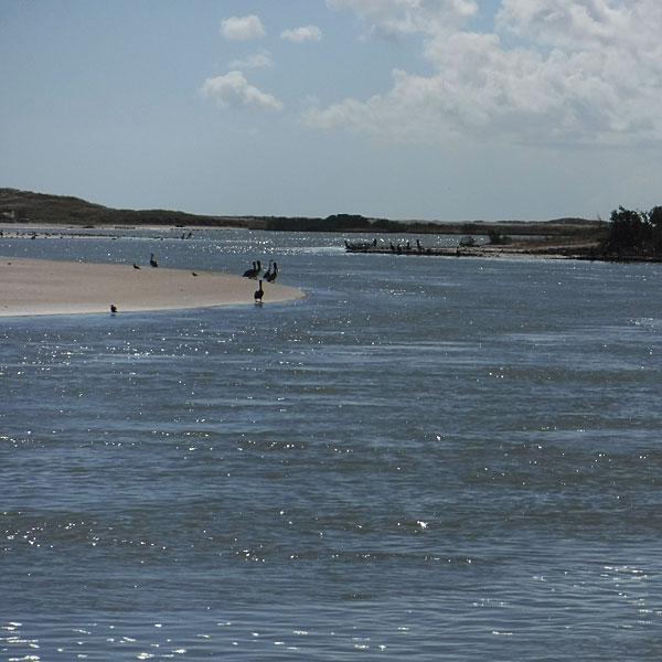
Looking toward the mouth of the Rio Grande
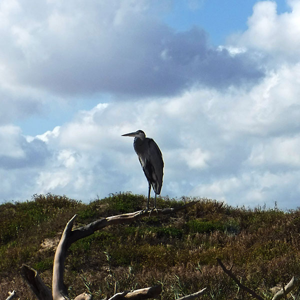
This wizened-looking heron appeared to be keeping watch over the beach at Boca Chica.
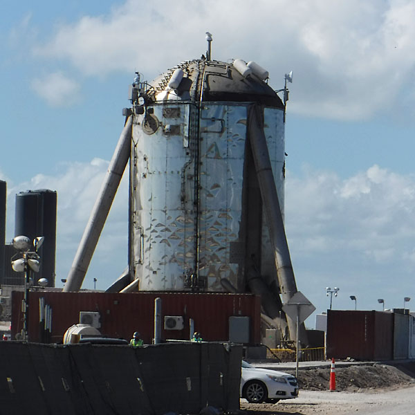
Our day trip had a dual purpose. The route brought us to incredible scenes of nature, but it also took us past an impressive manmade achievement. Boca Chica is the location for the SpaceX suborbital launch site, as well as the main production facility for SpaceX’s Starship spacecraft and SuperHeavy first-stage booster rockets. In combination, they comprise the system that SpaceX plans to use to carry crew and cargo to the moon, to Mars…and beyond (*cue the Star Trek theme song*).
There’s way too much to discuss about SpaceX’s presence in South Texas (visit the preceding link to fill in any knowledge gaps), and I don’t understand most of what we saw on this day trip, but here are a few photos to give you a sense of what’s down there.
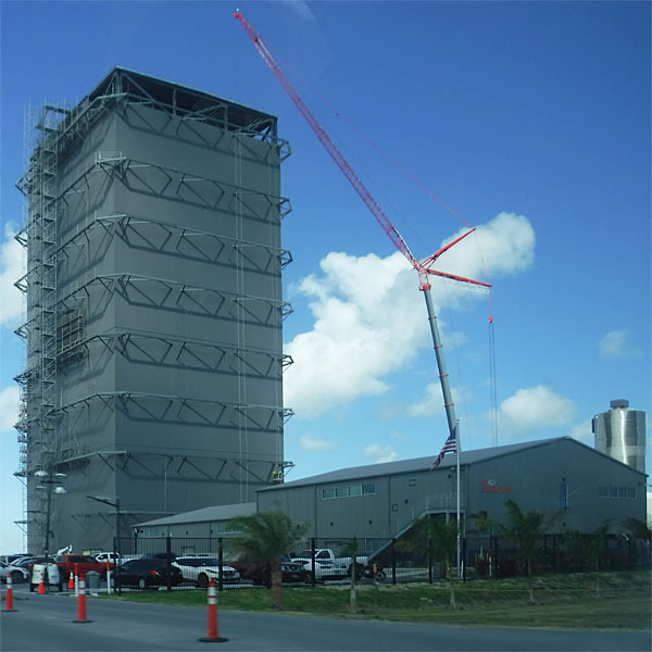
Part of the SpaceX production facility. If you could peek inside that tower, you might see a spacecraft under construction.
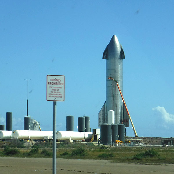
SpaceX’s Starship SN8 at the testing facility. I can’t believe they wouldn’t let me fly my drone there.
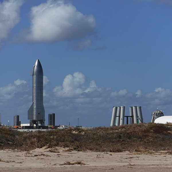
SpaceX’s Starship SN8 as seen from Boca Chica Beach, perhaps a mile away. I have no idea what the structure on the right is used for (platform for testing the Starhopper, perhaps?). Hey, Elon…you really need better signage, amigo.
Update (11/21/2020): My slightly better-looking but MUCH older cousin, Marshall, pointed me to this video which has a highly-educated guess about the purpose of the mystery structure shown in the photo above. The entire video is interesting, but the actual reference in question appears after the eleven minute mark.
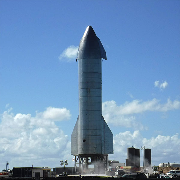
Closer view of SpaceX’s Starship SN8. That’s dust — not smoke or steam — blowing around the base. Interesting to note that Elon Musk has been quoted as saying the inspiration for the rocket’s shape comes from Explorers on the Moon, the 1950s Belgian comics series featuring Tintin.
This is the Starship Hopper or Starhopper, a low altitude vehicle previously used by SpaceX to test the rocket engines — named Raptors because why not? — and other components that will be used in the Starship. This one is now out of service, and has been repurposed for something else that’s probably classified and well above my pay grade.
Say, speaking of design inspiration…does that Starhopper remind you of anything else? Anything at all?
How about now…

Nothing new under the sun
You’ll recall that the Boca Chica launch site is about ten miles from SPI, as the crow flies. Ten miles seems like a long way, but Sam and Trish told us that when SpaceX fires up its test engines, the sound rattles their windows.
The next day, we hauled our kayak to a Gulf-facing beach on the north side of SPI. As I mentioned at the top of the show, foolhardy endeavors were bound to appear on the agenda at some point, and this day was that time. Sam and I had made a pact to see if the non-seagoing kayak could thrive — or at least survive — in the semi-pounding surf rolling in from the Gulf of Mexico.
According to Sea Eagle’s website, the 385ft is rated for Class II rapids, which are defined as those with regular waves… maneuvering required…handled by intermediates who can maneuver canoes and read water. Of course, this classification actually only applies to rivers, not to open ocean. And while we certainly were going to confront regular waves, the classification says nothing about how high those waves should be. And, finally, there’s that last requirement about the skill level of the kayak’s operator(s). We were emphatically lacking in all stated qualifications. In other words…bring it on!
Under the watchful eyes of our wives (Debbie was the videographer), who were remarkably calm, having already consulted our life insurance policies, Sam and I ventured bravely into the raging sea. I could exhaust my vocabulary describing what happened, but how about just watching a short video instead?
Pretty impressive, huh?
What you don’t see on the video is that by the time we confronted the second or third wave, the kayak was filled to the gunwales (that’s a real nautical term…I think) with water, as the waves were big enough to wash completely over us. It’s a testament to the design of the kayak that we never came close to sinking, and we could still maneuver it, albeit not gracefully.
The biggest problem with a kayak full of water is that it’s pretty dang heavy, so heavy that we couldn’t lift it out of the water when we returned to shore and could hardly even turn it over to empty it.
The other aspect that’s missing from the video is the fact that we didn’t get nearly as far into the Gulf as we thought or planned. We were so busy trying to stay upright and pointed into the waves that we made very little actual headway. It took us about a tenth of the time to return to shore as it did to get out into the Gulf, and that included the only time we capsized (we turned slightly sideways coming back in and an opportunistic wave took advantage of that mistake).
We were out less than twenty minutes, and arrived back onshore completely exhausted and bedraggled.
We can’t wait to do it again.
Our last full day SPI included church services at Island Baptist Church (where the pastor is an Aggie and joined me in celebrating a big football win over South Carolina the previous day) and kayaking/paddle boarding in the Bay. It was a good finale to a great getaway.
But we cannot close this chapter without remarking on the weather and the sunsets. It’s my observation that every region of Texas claims to have the best sunsets, but in all honesty, our home in the Hill Country is sub-par in that regard simply because of all the trees and, well, hills. But SPI has no such distractions, and the view from our hosts’ balcony offers exquisite views almost every evening.
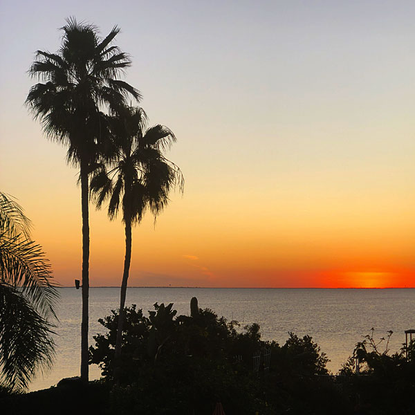
A typical sunset over Laguna Madre
But the weather there can be a bit…unusual. Don’t take my word for it; Weatherbug never lies.*
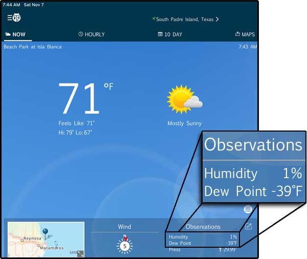
Does this look right to you?
If you’ve never been to SPI, you should consider adding it to your bucket list. It’s a special place, even if the humidity is off the scale.
*Weatherbug always lies.
Discover more from The Fire Ant Gazette
Subscribe to get the latest posts sent to your email.
Impossible not to have fun with such excellent guests! 🙂
You’re much too kind, Trish!